The proposed method aims to classify backscattered signals (such as full waveform data from aerial LiDAR), assigning to each detected point its class, according to the object hit by the signal emitted by the instrument (e.g., terrain, building or vegetation). The method uses a two-step procedure, that, thanks to the use of a classifier and a subsequent segmentation algorithm, makes it possible to exploit both the raw signal, the spatial position and the geometric relationships between neighboring points, obtaining an accurate and fully automatic classification.

Patent Status

PENDING

Priority Number

IT102018000005375

Priority Date

15/05/2018

License

INTERNATIONAL

Market

The technology developed can be exploited by different types of companies:

  • Companies that develop software for processing laser scanner data, which could complement their offer;
  • Companies producing laser scanners or related instruments, which usually also provide software for the use of the instruments themselves and the first steps of the data processing;
  • Companies operating in the field of remote sensing, which could have a direct impact on data processing time and costs.

Problem

LiDAR technology is widely used in remote sensing, as it allows to obtain a 3D model of the surveyed environment in the form of a point cloud, measuring the time taken by a short laser pulse to travel the distance between the instrument and the object to be measured.

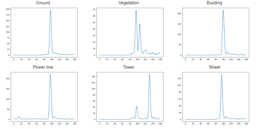
Among the different types of LiDAR sensors, the full-waveform laser scanner is able to record as a function of time the entire distribution of reflected energy from the surfaces hit by the laser pulse (waveform). Thanks to this data it is possible to obtain further information on the geometric and reflectivity properties of the target, useful in the classification phase. Classifying the laser data means assigning to each detected point its class, according to the object hit by the laser pulse.

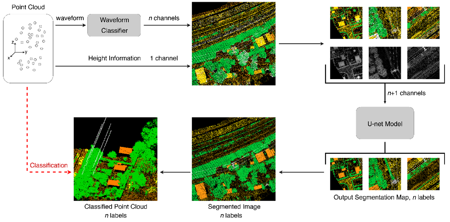
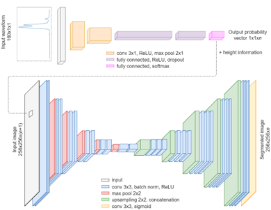
The patented solution aims to classify the data in two stages: in the first one, the raw waveform data is provided as input for a classifier. In the second step, the data is mapped into a two-dimensional image, in which each pixel contains the probability distribution vector provided by the classifier, and the height of the point falling into the pixel. A deep learning algorithm is then used to segment the image, assigning a label to each pixel. The method thus allows a fully automatic classification that, compared to current technologies, improves the achievable accuracy.

Current Technology Limits

Currently, the classification process still has many limitations, and the automatic solutions available on the market are not accurate enough in identifying the different objects in space. This implies a significant amount of work (in terms of time and cost) by an operator, who must manually correct errors generated by automated software. The proposed technology allows to realize a classification with accuracy higher than the state of the art, and allows to identify with precision also points belonging to classes that describe objects with a particularly reduced surface (e.g., power line cables). Moreover, when full-waveform laser scanners are used, the size of the data to be used in the classification phase requires very large memory spaces and high computing capacity, preventing, in many cases, their real use. The development of the proposed technology has allowed to implement a full-waveform data compressor, which can overcome the problem of the significant mass memory used for data storage.

Killer Application

The level of maturity of the technology makes it already potentially applicable to remote sensing projects that provide classified point clouds for analysis on objects and elements of the territory.

Among the possible applications, classifying the data is an essential step to:

  • Create digital terrain models (obtained only from points belonging to the terrain and road classes);
  • Perform analysis on data belonging to particular classes (e.g. assess vegetation density);
  • Automatically determine the relationships between different classes (e.g. distance between electrical cables and buildings).

Our Technology and Solutions

The developed product, being equipped with a stand-alone executable software, allows the companies operating in the field of remote sensing to be able to easily use it in order to realize the classification on their own data. Moreover, thanks to the data compression system developed, able to effectively reduce the size with minimal loss of information, companies can take advantage of the full-waveform signal by operating directly on compressed data, with significant reduction of the mass memory required for storing the raw data.

Vantaggi

  • fully automatic classification;
  • superior performance to the state of the art;
  • ability to accurately detect even points belonging to classes that describe objects with a particularly small surface area (e.g., cables of a power line);
  • possibility to compress the full-waveform data;
  • once the training of the neural networks has been performed, the user does not have to define any parameter that can influence the obtainable result.

Roadmap

Thanks to the increased degree of maturity of the patent obtained through the design activities, it is now considered possible to effectively involve companies operating in the field of remote sensing, that can test on their own data the implementation of the patented classification method. Cooperation with them could allow access to new datasets, useful both for testing the software made, and for an improvement of the method through a more generalized training of the networks.

Review the Technology
TRL 1
TRL 2
TRL 3
TRL 4
TRL 5
TRL 6
TRL 7
TRL 8
TRL 9

TRL

Team

Menu