The “RES-Plat” platform allows users to analyze, in an integrated way and from a planning perspective, the multi-dimensional impacts of the exploitation of renewable energy sources (RES), with particular reference to wind and solar photovoltaic. It allows us to know, through an interactive cartographic representation, of the exploitable potential, and to evaluate, at different territorial scales (country, region, district) the energy producibility, with hourly granularity, of various technological solutions, the financial impact of the investments and related environmental effects.

Patent status

GRANTED

Priority Number

Time-stamped software

Priority Date

16/07/2020

License

INTERNATIONAL

Market

Investments in renewable sources – under the energy transition perspective – are already significant and expected to grow in the next years; in this regard, for Italy alone, the National Integrated Energy and Climate Plan estimates an additional investment of € 186 billion by 2030, while the Confindustria White Paper quantifies it at € 126 billion. The availability of planning tools like RES-Plat, able to allow for the analysis of alternative scenarios (also in terms of financial impacts), will therefore become increasingly important for the involved investors and operators.

Problem

The energy transition towards decarbonisation is currenty an unavoidable necessity, in order to counteract the negative impacts on the environment (in terms of climate change related to global warming) and on human health (with reference to the air pollutant emissions). This implies a progressive replacement of fossil sources in the energy mix of individual countries, which involves significant changes of paradigm, with a shift towards technological solutions fueled by non-fossil commodities and with effects not only in terms of environmental sustainability but also of economic accessibility and security. In this context, a fundamental role is played by electricity produced from renewable sources (RES), such as wind and solar photovoltaics, coupled with the electrification of end uses. In particular, the production of electricity from RES requires timely planning of the investments to be made, taking into consideration both the potential resources of the territory and the technical characteristics of the technologies adopted. For this reason, the possibility of carrying out integrated analyzes by using innovative tools that allow to take into account the environmental and morphological peculiarities of the sites and to estimate the impacts of different alternative solutions in a multidimensional perspective (i.e. not only from an energy perspective, but also in terms of sustainability and economy) is becoming of primary interest.

Current technologies limits

Currently, the available commercial software systems allows the evaluation of production from renewable sources and the components sizing, but they are mainly design software systems, aiming at identifying the size of plants to be installed in order to meet the given energy needs. Such software does not allow an easy planning of large-scale renewables. In fact, it is often not possible to quickly make a comparison between different technologies and configurations for large geographical areas, and the basic morphology criteria of the territory are not taken into account for the installation of the systems. Furthermore, these tools usually do not allow for an integrated assessment of environmental and economic benefits. Among the alternative solutions for planning, we can mention the large-scale experimental measurement campaigns and the installation of “demo” plants distributed throughout the territory, which however require long times and often imply prohibitive costs, in particular when the planning concerns large geographical areas (for example, an entire country), and the use of weather data databases to promptly and iteratively evaluate the potential of each individual site of interest through specific models, also in this case with timelines long that hinder the planner / stakeholder work.

Killer Application

The RES-Plat platform has already found practical application as a tool for scenario analysis in the drafting of the ENEMED – Med & Italian Energy Report 2020, focused on the assessment of the renewable sources potential  for the construction of a new energy dialogue in the Mediterranean area and written in the framework of a joint collaboration among the ESL @ Energy Center – Politecnico di Torino laboratory, the study center of the Intesa Sanpaolo bank “Studi e Ricerce per il Mezzogiorno” (SRM) and the Joint Research Center (JRC) of the European Commission. The goal is to make the platform a tool for providing customized answers to specific instances in terms of renewable energy planning proposed by different types of stakeholders (institutions and public bodies, energy companies, investors, other research centers and think tanks)

Technology and our solution

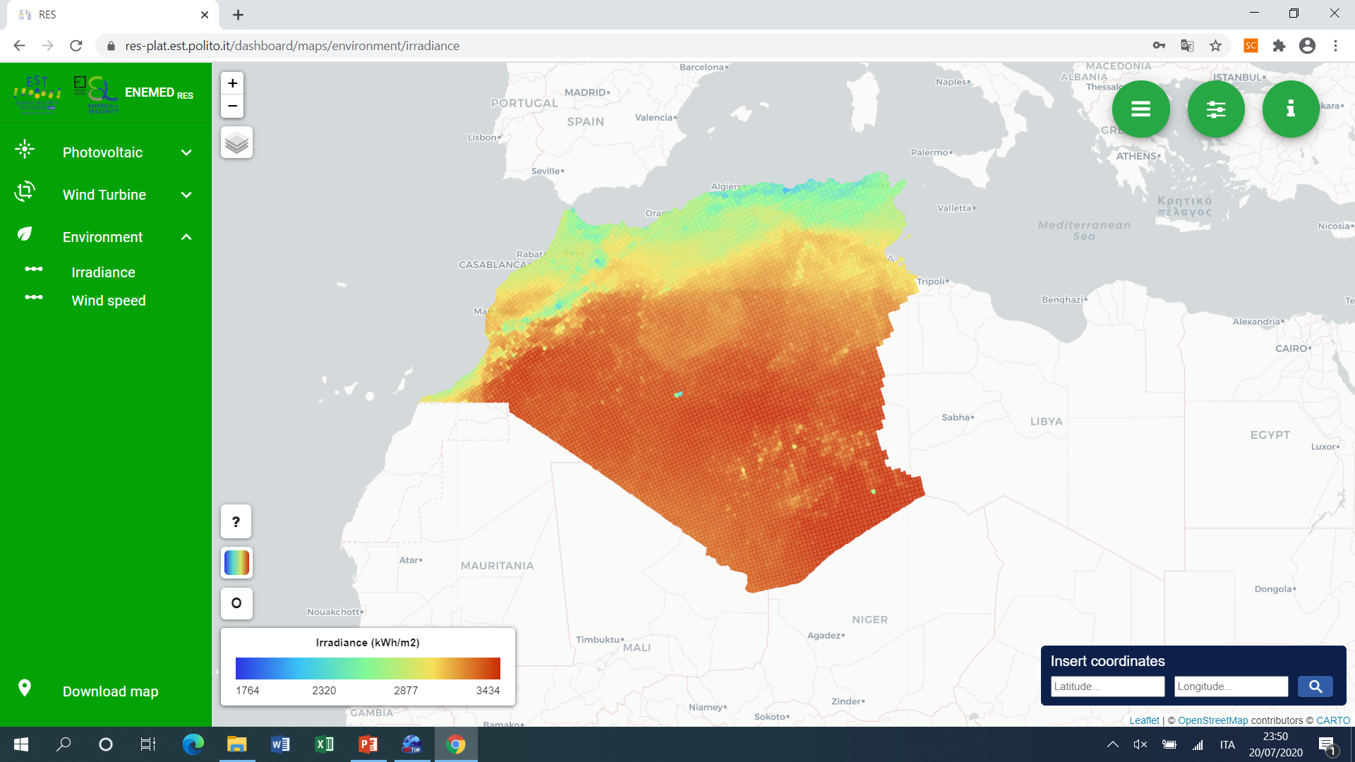
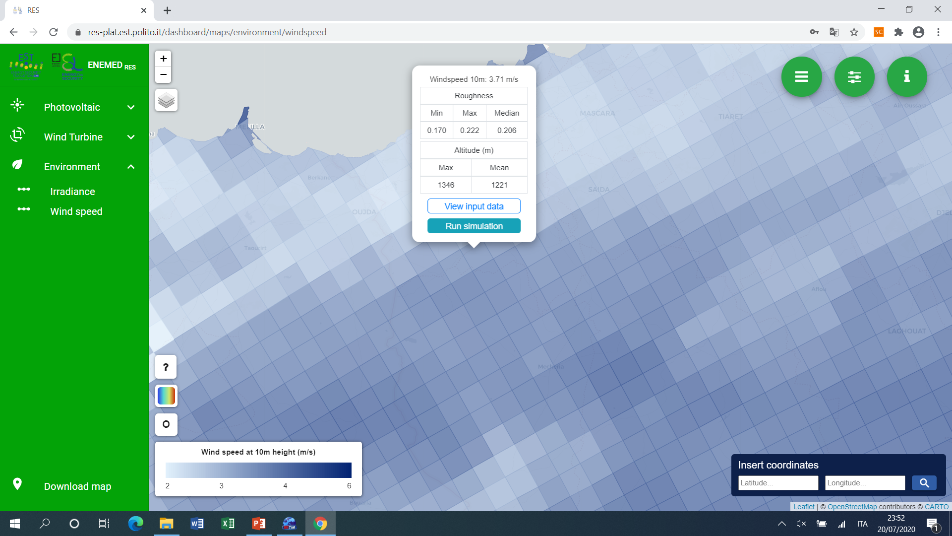
The goal of the RES-Plat platform (available online, with access reserved to registered users) is to provide an integrated solution that couples a database specifically developed for the purpose, an interactive geo-referenced representation, the implementation of mathematical models and an user interface devoted to the energy, environmental economic analysis of energy systems, with particular reference to RES. It is based on a proprietary database, powered by different publicly available datasets, from which information relating to different parameters (global radiation, air temperature, wind speed, altitude, type of terrain, roughness of the terrain) is extracted, and it is organized in 6 sections: Maps (display of the producibility maps associated with different photovoltaic and wind technologies, of irradiance and wind speed, according to various administrative subdivision levels); Data (exploration of the data contained in the database); Manage DB (possibility to make changes to the database and to the configuration parameters of maps and simulations); Cases (possibility to view the previously built cases or to create a new case); Analysis (carrying out simulations, through the calculation kernel); Results (visualization of the results, in terms of electricity production with different time granularity, financial metrics and environmental impacts). The platform has some innovative features, including the complete integration of the interactive cartographic section, which allows a precise analysis of the characteristics of the territory and the definition of different criteria of suitability / non-suitability of a site according to the technology to be installed and to physical, environmental and topological parameters, thus allowing to have a pre-screening of the analyzed territory.

Advantages

Compared to the solutions currently available, the platform stands out for some peculiarities:

  • the installation of systems powered by RES decided with criteria for optimal exploitation of the territories, based on geomatics and distinguished on the basis of the adopted technologies: for photovoltaics, the technology is chosen according to the percentage of built-up area; for wind turbines only the territories with the appropriate morphology, altimetry and temperature in the presence of low built surface are chosen;
  • the possibility of obtaining, in the analysis, through the simultaneous knowledge of generation and consumption profiles, the optimal compromise between maximizing energy self-sufficiency with respect to total consumption and maximizing self-consumption with respect to production from RES;
  • the integrated analysis of energy producibility, environmental sustainability and financial impact.

Roadmap

Starting from the RES-Plat platform, a project is underway to create a modular platform of thematic “apps”, each dedicated to individual commodities (terrestrial and marine RES, single fossil sources, …) or to the study of the evolutionary trend of energy systems according to the energy transition, for the analysis of multi-layer scenarios, with integrated assessments of energy, financial and environmental impact. The apps (one of which will be the RES-Plat platform, further developed with the extension of the geographical coverage, the inclusion of further library functions and the refinement of the geomatic analysis) will communicate with each other, to provide customized answers to the instances from various stakeholders from the institutional, industrial and research world.

Review the Technology
TRL 1
TRL 2
TRL 3
TRL 4
TRL 5
TRL 6
TRL 7
TRL 8
TRL 9

TRL

The team

Menu